Most people know that polar bears rely on a platform of sea ice to reach their seal prey, but they may not realize that all sea ice across the Arctic is not created equal. In fact, my work has shown that polar bears roam across four distinct sea ice habitats—or ecoregions—across the Arctic. These ecoregions differ in sea ice freeze-up, break-up, and drift patterns. Also, ice among and within ecoregions may lie over ocean waters that vary greatly in productivity. Ultimately, we will lose sea ice, and the polar bears that depend on it, in all four ecoregions if societies do not stop global warming. The differences in ice character and ocean productivity, however, mean that the impacts of warming on the 19 different polar bear populations living within the four ecoregions are, and will continue to be, very different.
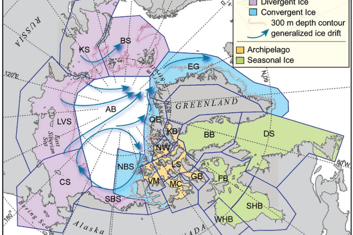
Photo: Excerpted from Amstrup et al. 2008
Four Sea Ice Ecoregions
By Dr. Steven Amstrup, Chief Scientist
6 MINS
04 Jun 2021
In a 2008 paper, I defined the four Arctic sea ice ecoregions as follows:
Seasonal Ice Ecoregion
The polar bear habitats in much of central and eastern Canada lie within the Seasonal ice Ecoregion (SIE), where, unlike the rest of the Arctic, the sea ice always has melted entirely in summer, forcing bears ashore, where there is little to eat. During the ice-free periods, polar bears must live off their fat reserves until the ice forms in the fall and they can hunt seals again. In the past, polar bears thrived in this seasonal environment because it almost entirely encompasses shallow water over the productive continental shelf. The rich environment allowed polar bears to gain enough weight in spring to survive a long summer fast. The impact of global warming on bears throughout the Seasonal Ice Ecoregion is that the ice is melting earlier in the spring and freezing up later in the fall, and the bears are food deprived for an ever longer period. Much of the Seasonal Ice Ecoregion occurs at the southern extreme of the polar bear's range. Bears in southern Hudson Bay, for example, currently live at the same latitude as Scotland. The number of ice-free days faced by these “southern bears” in Hudson Bay is already impacting the survival of cubs, because mother bears there increasingly can’t gain enough weight in spring to provide sufficient milk.
Divergent Ice Ecoregion
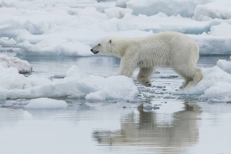
Across the rest of their range, polar bears used to be able to stay on perennial ice (ice that survives the summer melt) year-round. In the Divergent Ice Ecoregion (DIE), which extends around the Arctic from coastal Alaska to Svalbard, ocean currents continually carry the ice offshore as it forms. This movement of ice “diverging from the shoreline” is especially noticeable in summer. As the weather warms, new ice stops forming and the remaining ice drifts toward the center of the polar basin, leaving a gap of ocean water between land and the polar ice pack. Historically, the summer ice retreat was small and these bears were able to hunt on the ice over productive shallow water all summer, reaching peak body weights by fall. As the sea ice retreats farther and farther from shore in a warming Arctic, however, these polar bears are faced with a choice of coming ashore, where there is little to eat, or following the sea ice over the deep polar basin where productivity is very low. Because seals can live a totally pelagic lifestyle, they don’t need to follow the ice and instead remain nearer shore where productivity is high. Polar bears remaining on the ice, like those that come ashore, are food deprived, and end up fasting until autumn freeze-up. Five polar bear populations live in divergent ice areas: Barents Sea, Chukchi Sea, Kara Sea, Laptev Sea, and the Southern Beaufort Sea. Long fasts for these bears which, unlike those in the seasonal ice ecoregion, are accustomed to feeding through the summer, make them among the most vulnerable of all polar bears to warming and sea ice decline.
Convergent Ice Ecoregion
In the Convergent Ice Ecoregion (CIE), ice transported from the Divergent Ice Ecoregion, along with locally formed sea ice, collects along the shore. The collection of ice along coastlines provides polar bears with access to seals over productive waters throughout the summer, and, at least for now, these bears can still remain on the sea ice all year. Three polar bear populations live in these areas: Eastern Greenland, Northern Beaufort Sea, and the Queen Elizabeth Islands.
Archipelago Ecoregion
The ocean channels separating the islands of the far north Canadian Arctic have historically been covered by sea ice all summer, and polar bears living there have been able to remain on ice all year long.
This Archipelago Ecoregion (AE), along with the northernmost portions of the Convergent Ice Ecoregion, is likely to provide a last refuge for polar bears and their sea-ice prey. Six polar bear populations live in the Archipelago Ecoregion: Gulf of Boothia, Kane Basin, Lancaster Sound, M'Clintock Channel, Norwegian Bay, and the Viscount Melville Sound.
Without action to halt global warming, even the farthest north polar bear habitats will lose their ice. Until societies stop global warming, the impact on polar bears, will depend on how many ice-free days polar bears face in different areas, and how much weight polar bears can gain during periods when the ice is present.
Map legend
The Divergent Ice Ecoregion (DIE) (purple) includes Southern Beaufort Sea (SBS), Chukchi Sea (CS), Laptev Sea (LVS), Kara Sea (KS), and the Barents Sea (BS). The Convergent Ice Ecoregion (CIE) (blue) includes East Greenland (EG), Queen Elizabeth (QE), and Northern Beaufort Sea (NBS). The Seasonal Ice Ecoregion (SIE) (green) includes Southern Hudson Bay (SHB), Western Hudson Bay (WHB), Foxe Basin (FB), Davis Strait (DS), and Baffin Bay (BB). The Archipelago Ecoregion (AE) (yellow) includes Gulf of Boothia (GB), M’Clintock Channel (MC), Lancaster Sound (LS), Viscount-Melville Sound (VM), Norwegian Bay (NW), and Kane Basin (KB).
Reference
Amstrup, S.C.; B.G. Marcot; and D.C. Douglas (2008), A Bayesian Network Modeling Approach to Forecasting the 21st Century Worldwide Status of Polar Bears, in Arctic Sea Ice Decline: Observations, Projections, Mechanisms, and Implications. Geophys. Monogr. Ser., Vol 180, edited by E.T. DeWeaver, C.M. Bitz, and L. B. Tremblay, pp. 213-268, AGU, Washington, D.C., Mechanisms and Implications. Geophysical Monograph 180. American Geophysical Union, Washington, D.C.


